


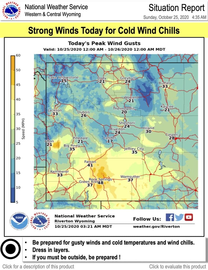
CASPER, Wyo — Bitterly cold temperatures with wind chill values below zero in many places will prevail Sunday and Monday in Wyoming, according to the National Weather Service (NWS) Riverton.
The majority of snow will move out of the western and central region by Sunday afternoon, NWS said. Skies will clear tonight with the passage of system, which is when the coldest temperatures will set in.
“This is the big story right here, not the snow, it’s the cold temperatures” said Chris Hattings, NWS Riverton Meteorologist in a Saturday video update.
Article continues below…

“High temperatures will be in the teens for the most part with single digits in most mountains. Some lower elevation spots will struggle to 10 above. Thus record low high temps will occur just about everywhere,” said NWS.
-20 degree temperatures could affect some of the lower valleys, NWS said. The snow is reported to be light and fluffy, making it easier to shovel but more likely to blow and drift, affecting travel routes.
Casper extended forecast
Sunday
Snow showers will continue and begin to clear around 2:00 pm, bringing an additional 1 to 2 inches of accumulation.
High temperatures will be near 11 degrees, with wind chill values as low as -10. Northeast winds 13 to 16 mph, with gusts as high as 24 mph are expected.
Sunday Night
A 20 percent chance of snow before 8:00 pm. Cloudy, then gradually becoming partly cloudy, with a low around -7. Wind chill values as low as -20. Northeast wind 5 to 11 mph becoming west southwest after midnight.
Monday
“Sunny, with a high near 21. Wind chill values as low as -20. Southwest wind 5 to 11 mph.
Monday Night
Mostly clear, with a low around 3. South southwest wind around 11 mph.


-335x186.jpg)
.jpg)
Man charged with breaking into Premium Towing company | News