


Hurricane Laura is expected to make landfall in southwestern Louisiana as a major hurricane.
Accuweather
PORT ARTHUR, Texas — Hurricane Laura is expected to be an “extremely powerful Category 4 hurricane” with “unsurvivable storm surge” when it reaches the Gulf Coast on Wednesday night and early Thursday, the hurricane center said in its 10 a.m. CDT update.
Laura, which grew to a Category 3 storm early Wednesday, is forecast to bring “potentially catastrophic” storm surge, fierce winds and flash flooding to eastern Texas and Louisiana, the National Hurricane Center said.
More than half a million people were ordered to evacuate as the storm approached, including the Texas cities of Beaumont, Galveston and Port Arthur.
The storm has already intensified a “remarkable” amount in the past 24 hours, the storm center says.
Laura is growing in size, too. “Hurricane-force winds extend outward up to 70 miles from the center and tropical-storm-force winds extend outward up to 175 miles,” forecasters said.
The storm, moving northwest at 16 mph, was last spotted 225 miles south-southeast of Lake Charles, Louisiana, and 235 miles southeast of Galveston, Texas, as of 10 a.m. CDT Wednesday. Wind speeds had increased to up to 125 mph, which is a Category 3 major hurricane. It’s the first major hurricane of the 2020 season.
“We are expecting widespread power outages, trees down. Homes and businesses will be damaged,” said Donald Jones, a National Weather Service meteorologist in Lake Charles, Louisiana.
“I’m telling you, this is going to be a very serious situation,” Jones said.
‘Rapid intensification’: Why Laura could be so dangerous
More: Fifteen years and $15 billion since Katrina, New Orleans is more prepared for a major hurricane – for now
The hurricane center says parts of the coast from Johnson Bayou, Louisiana, to the Rockefeller Wildlife Refuge, could see waters rise as much as 20 feet due to “the combination of a dangerous storm surge and the tide.”
Storm surge could reach as far as 30 miles inland from the immediate coastline, the hurricane center added. “Actions to protect life and property should be rushed to completion as water levels will begin to rise later today.”
Port Arthur, Texas, was mostly boarded up and deserted Tuesday evening, as residents fled from the low-lying region.
“If you decide to stay, you’re staying on your own,” Port Arthur Mayor Thurman Bartie said.
Emergency officials with Jefferson County, which includes Port Arthur, staged a number of “hubs” to collect residents and transport them to other areas around Texas, rather than shelter them there, said Allison Getz, a county spokeswoman. A key reason for doing it that way was concerns over the coronavirus pandemic, which makes it hard to shelter large groups of people in one place, she said. Only 15 to 20 people will be placed on buses, instead of the usual 50, she said.
“This is not just a flood like we’ve experienced in the past,” Getz said. “It has a wind component that really could be deadly.”
At the Robert A. “Bob” Bowers Civic Center, 14 tour buses lined up to ferry away residents who couldn’t evacuate themselves, many of them elderly or handicapped. Robert Bailey, 68, has lived in Port Arthur since he was 9 and has stayed for every storm that’s hit the area – until now.
“This is a double whammy,” he said as he boarded a bus headed for Huntsville, Texas, with friend Louise Green. “We don’t know what it’s going to be like.”
Flying? Change your Gulf Coast flight without a fee
How to prepare: Response guide for any emergency situation
Not everyone was leaving. Simike Babineaux, 38, filled sandbags at a pavilion in downtown Port Arthur as her two kids, Hayden, 8, and Haleigh, 7, happily climbed the mounds of sand. Babineaux said she would like to get out of Port Arthur but was afraid of exposing her children to the coronavirus during evacuation.
“It’s stressful,” she said. “You want to go but you don’t want to go because you might get (the virus). So, we’re probably going to ride it out.”
The hurricane is threatening a center of the U.S. energy industry. The government said 84% of Gulf oil production and an estimated 61% of natural gas production were shut down. Nearly 300 platforms have been evacuated.
After Laura makes landfall, the storm is expected to weaken rapidly as it makes its way north then turns northeast.
The storm is also expected to bring as much as 15 inches of rain in some isolated pockets in Louisiana and Texas. A few tornadoes could also be seen in Louisiana, far southeast Texas, and southwestern Mississippi, the hurricane center says.
The most recent major hurricane to make landfall in Texas was Harvey in 2017, with 130 mph maximum winds, said Colorado State University meteorologist Phil Klotzbach. In Louisiana, it was Rita in 2005, with 115 mph maximum winds.
The Atlantic hurricane season has been a record-breaker. Laura is the earliest L-named storm in the Atlantic Basin, breaking a record held by Luis, which formed Aug. 29, 1995. This season has had 13 named storms, which is well above-normal activity.
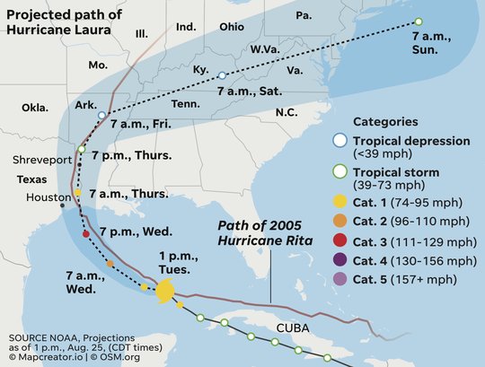
Projected path of Hurricane Laura as compared to Hurricane Rita (2005) (Photo: Janet Loehrke / USA TODAY)
Rick Jervis reported from Port Arthur, Texas. Contributing: The Associated Press
To get more daily updates on Hurricane Laura, click ‘play’ below:
Read or Share this story: https://www.usatoday.com/story/news/nation/2020/08/26/hurricane-laura-path-update-storm-category-4-texas-louisiana/3441543001/


