


MIAMI (CBSMiami) – Tropical storm conditions from Hurricane Isaias are spreading over the Central Bahamas.
At 2 p.m., Friday, the center of the storm was about 245 miles southeast of Nassau, Bahamas.
It was moving to the northwest at 16 mph with maximum sustained winds of 75 mph. Hurricane-force winds extend outward up to 35 miles from the center and tropical-storm-force winds extend outward up to 205 miles.
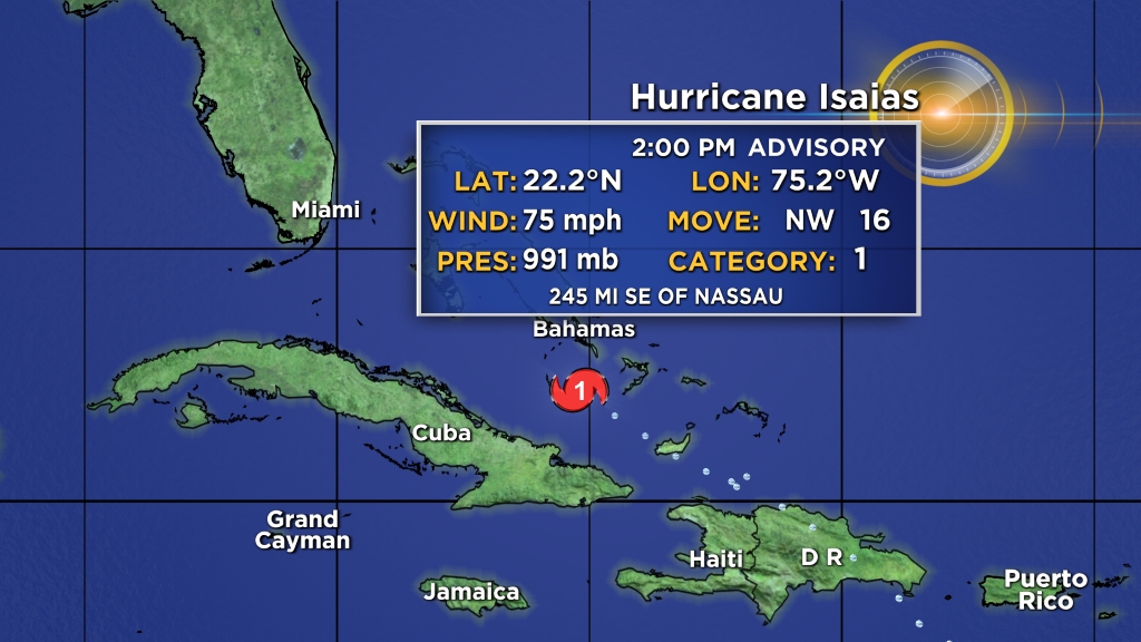
Some strengthening is possible on Friday and Isaias is expected to remain a hurricane for the next few days.
Isaias is forecast to continue moving to the northwest and slow down over for the next couple of days, it will then take a turn toward the north-northwest.
On the forecast track, the center of Isaias will continue to move near or over the Southeastern Bahamas on Friday. Isaias is forecast to be near the Central Bahamas Friday night, and move near or over the Northwestern Bahamas Saturday and near the east coast of the Florida peninsula Saturday afternoon through Sunday.
A Hurricane Warning is in effect for:
- Northwestern Bahamas including Andros Island, New Providence, Eleuthera, Abacos Islands, Berry Islands, Grand Bahamas Island, and Bimini
- Southeastern Bahamas including the Acklins, Crooked Island, Long Cay, the Inaguas, Mayaguana, and the Ragged Islands
- Central Bahamas, including Cat Island, the Exumas, Long Island, Rum Cay, and San Salvador
A Hurricane Watch is in effect for:
- North of Deerfield Beach to the Volusia-Brevard County Line
A Tropical Storm Warning is in effect for:
- Turks and Caicos Islands
- North of Ocean Reef northward to Sebastian Inlet
- Lake Okeechobee
Interests elsewhere along the southeast coast of the United States should monitor the progress of Isaias.
INTERACTIVE TROPICAL TRACKER
Tropical storm conditions continue across portions of the Turks and Caicos. Hurricane conditions in the southeastern Bahamas will spread northwestward into the central and northwestern Bahamas Friday night and into Saturday.
Tropical storm conditions are expected in the warning area in Florida beginning Saturday. Hurricane conditions are possible in the Hurricane Watch area beginning Saturday night and continuing into Sunday.
South Florida into east-Central Florida could get 2 to 4 inches of rain with isolated maximum totals of 6 inches.
RELATED: HURRICANE 2020: PREPARING IN A PANDEMIC


