


This will be the last blog for about 10 days or so aside from a new podcast blog tomorrow morning. Each year I head out for a golf vacation in Arizona and I’ll be leaving in the next few days. This works on many levels for me because the heat is intense (usually) in AZ (but it’s a dry heat)…and the golf is a lot cheaper in the summer out there than in the winter. So VERY expensive courses in the winter are just thrilled to see anyone play during the summer so they cut their prices a lot.
Usually I get away when their isn’t a lot of weather locally as well. Things usually settle down in late July through mid August…and that appears to be the case for awhile here.
I used to crank out a blog or two or 10 while I was gone…this time though I think I’ll take some days away from the blog. I might get one or two out IF I have time but sometimes that 2 hour difference makes things tough and I play golf out there in the morning so that makes it even tougher.
I will be checking in on FB and Twitter though as usual so you can always get a hold of me that way.
Not a lot happening locally this week…we’ve enjoyed some really nice weather with dew points that have been persistently low since Monday morning.
We’re not alone in this either. Dew points remain pretty low all the way down towards near the Gulf Coast…there have been a few days of record lows down there too with the dry air allowing overnight lows to tank.

The highest dew points this morning is across the upper Midwest. Heck mid 60 dew points in AL/MS is pretty darn good for them during the end of July
South winds in place for the next few days will gradually start to bring moisture northbound but even Saturday won’t be overly oppressive.

Not a lot of change from today really…so yes warmer by a couple of degrees but still pretty OK comfort-wise.
On Sunday though the dew points will be back to near 70° or so. That will be a factor in the next front coming in Sunday night into Monday AM. As the moisture increases at the surface and aloft storms should fire up later Sunday to the northwest of here and drift through the area Sunday night into early Monday AM. At this point everything looks to blow through pretty quickly.
It doesn’t look like it will be a huge event (unlike the last set of storms last Saturday night/Sunday). These should move along nicely and won’t last as long. We’ll be needing the rain because this great weather sucks out the soil moisture pretty quickly.
IF you miss out on the rain Sunday night…then the chances next week are there too…
The reason is because we’re going to be somewhat on the edge of the hotter weather and the less hot weather. Hotter stuff will be out west…less hot stuff will be to the northeast. We’re in this zone for most of the week that means that we should see our typical summer heat with temperatures well into the 80s to lower 90s. With the near 100° heat out west and the somewhat more cool air to the east, occasional storm chances will be around.
The flow aloft should be more of a NW to SE flow..which means that we’ll be watching the western and northern Plains for disturbances to come down…how well they hold together and how much rain they bring us remains to be seen but the chances will be there off and on next week.
The GFS model ensembles are more excited about something on Wednesday…

While the EURO ensembles are more excited about something next Friday…

The models from this far out will perform poorly in trying to time out any wave that won’t exist for days to come. What you glean from them though is the “set-up”. I may not be specific on which days it may rain on the forecast tonight but I would probably say something along the lines of “there will be additional chances next week and we’ll work through those as we get closer.
Assuming we don’t get into the nastier heat out west…that the “heat wave generator” stays more towards the Rockies for most of the next 10 days…we’ll just have typical early August weather it appears with a few less hot days and a few warmer days.
OK that’s all…blog tomorrow will be a podcast blog. I talked to the Emergency Manager of Leavenworth County yesterday about the tornado in the Linwood area and it’s associated issues both the day of and the days after.
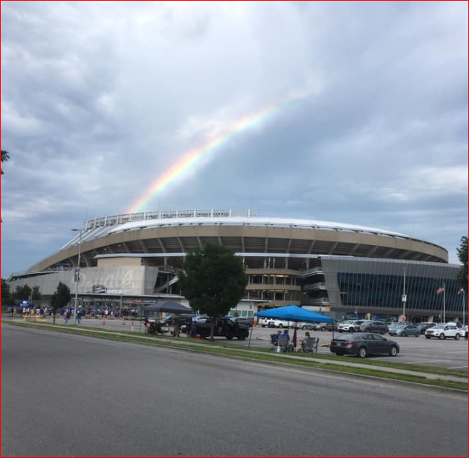
Our feature photo of the day is from Mark Rebecca Gibson who shot this rainbow over the K last night!

Joe


%20|%20FOX%204%20Kansas%20City%20WDAF-TV)